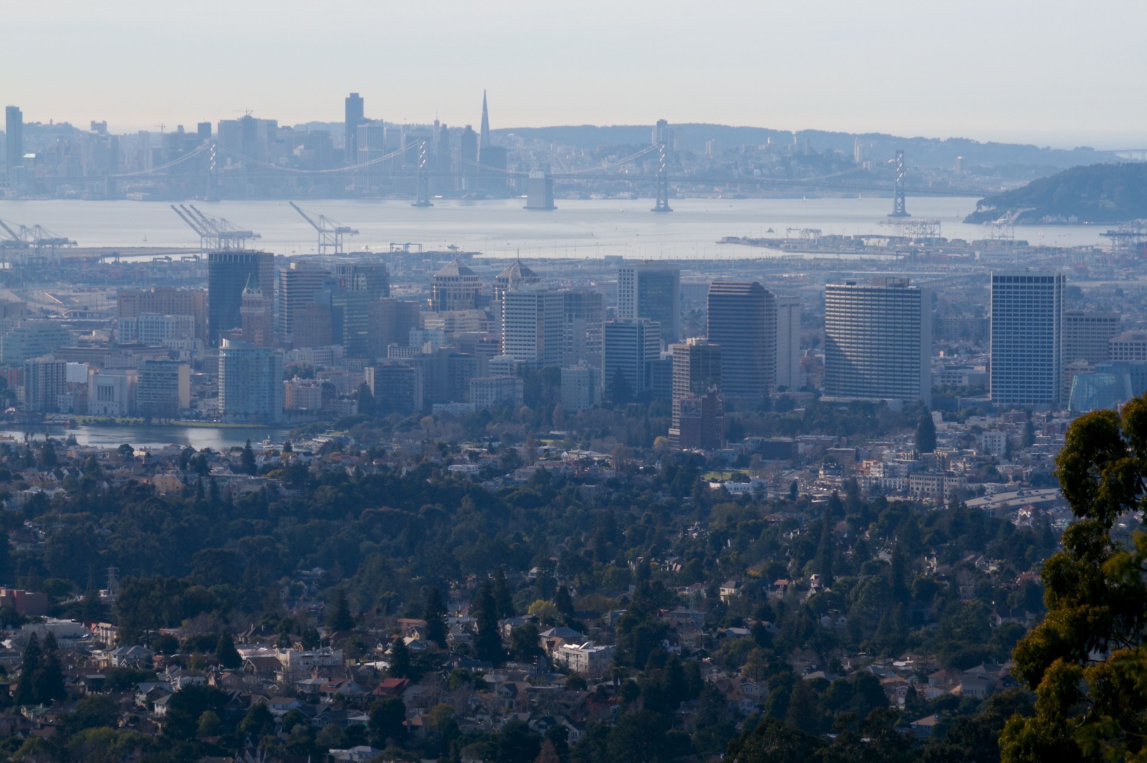
Oakland from Skyline Dr. showing the city’s downtown and port as well as its central location in the Bay Area.(Photo by Jesse Richmond via Flickr)
Introduction
In this article, which will be the first in a series of four, I will propose and give an overview of my proposal to bring trams to Oakland. This article will give a very bare-bones look at the system, with a brief look at each line, and some background about why the system should exist. The following two posts in this series will explore each of the two proposed lines in detail, exploring alignment possibilities, necessary ROW changes, intensive demand forecasting, and more. Finally, the last post will explore the political and financial feasibility of the system and will explore how the system might come to be a reality. For now, however, I present the Oakland Tram Project!
Background
The Bay Area is the 5th largest metropolitan region in the country with roughly 9 million people1, and one of the most important regions in the world. The region plays host to hundreds of companies and has the 4th highest GDP for a metropolitan area in the world2. And right in the middle of this region, lies Oakland. Oakland serves as the transportation backbone for the Bay Area, in terms of roads, freight, and most importantly for this article, transit. Oakland has the most BART stations of any city3 on the system and is in many ways the center of the system. Capitol Corridor trains, run from Sacramento through Oakland to San Jose, connecting California’s capitol to Silicon Valley. Essentially, Oakland is the heart of Bay Area transit.
Despite this, it often feels like Oakland gets less attention than it deserves. Particularly in regard to high-quality transit, Oakland has not received the same attention or funding that other cities have. Oakland’s transit situation has been deteriorating for a long time now4, and it’s time to see a real investment in transit in Oakland that serves locals. This is why I am proposing a new rapid transit system for Oakland; a 2-line tram system fitting for a transportation hub, and one that could help bring Oakland public transit into the 21st century.
Fertile Ground for Transit
Oakland, along with Fresno, is one of two cities in California with more than 400,000 people without a light rail or tram system. Despite this, many people in the city already take public transportation, with ~19% commuting primarily via transit, and only 49% driving alone to work (far lower than the 68.7% and 65.5% averages of the US and California respectively). This also puts Oakland in line with Seattle and puts its transit mode share closer to Philly’s than to Atlanta’s or Portland’s. Additionally, Oakland has a long history with transit, and many of its streets are still built for streetcar service, a legacy of the old Key System.
| City | Percent Commuting by Transit | Percent Commuting by Car (includes carpooling) |
| Oakland | 18.77% | 58.32% |
| Seattle | 17.85% | 47.02% |
| Chicago | 23.39% | 55.80% |
| San Francisco | 27.76% | 37.21% |
| Boston | 27.98% | 42.03% |
| Philadelphia | 21.38% | 56.68% |
| Portland | 9.62% | 61.35% |
Aside from its already high transit usage, Oakland is relatively dense for an American city5, in terms of both population and jobs. Population density in the local area is one of the most important factors in the success of a transit line, and therefore, one of the most important factors in whether a given investment in new rail transit is worth it6. Therefore, it is worth noting that Oakland has many areas of extremely high population density.

Map of Oakland’s density showing dense areas in Lakeside, Adams Point, Oak Tree, and more. Data from ESRI, 2024 US Census Bureau data.
In the map above, you can see that Oakland’s dense areas are concentrated primarily around Lake Merritt (particularly on the north side in Adams Point) as well as in residential areas along the International Blvd. Corridor. In fact, nearly all the block groups south of the lake along the International corridor between Lake Merritt and Hegenberger have population densities between greater than 17,500, making these areas as dense as neighborhoods in San Francisco like The Castro, Cole Valley, and the Inner Sunset, all of which are served by San Francisco’s light rail Muni Metro. 16,000/sq mi. is typically considered sufficient to support light-rail transit7 and make the International Corridor and lakefront more than dense enough to justify building light-rail. The city has also seen huge population growth in recent decades, with a population increase of nearly 13% from 2010 to 2020. Furthermore, much of this growth has been along the International Corridor as well as in Uptown8. The fact that these areas are only growing in population means demand for transportation will only rise, which only strengthens the case for better transit infrastructure in these dense areas.
Beyond population, Oakland also has many high-density pockets of employment. There are ~223k jobs in Oakland9, most of which are concentrated in the Downtown and along the southern bay-shore. In Downtown Oakland alone there are almost 40,000 jobs, many of which are surely worked by people living in and around the population-dense corridors already mentioned. Because most jobs in Oakland are concentrated in a handful of areas, in order to increase transit ridership, it is essentially to serve these areas with fast, reliable transit.

Map showing job concentrations in Oakland and Alameda. Notice the concentration of jobs in Downtown and the ports, as well as the concentrations around Oakland High School, Alta Bates/Mosswood, and near Kaiser.
It is worth noting too, that many of these job-rich, population-dense areas are part of Oakland’s ‘equity priority’ neighborhoods. Oakland was heavily redlined, and there are many areas where discrimination of the past still effects residents today. Compare for instance the redline map with a map of those equity priority communities:


Redlining map per University of Richmond mapping inequality project. Equity priority data from Oakland’s geographic equity toolbox which can be found here.
The Plan


A map of both proposed tram lines10. Click to enlarge.
Introduction
In order to provide Oakland residents and workers with better transportation I propose that the city add two tram11 lines. These 2 tram lines would fill a large gap in Oakland’s current transit network in many ways. As previously mentioned, in coming posts, I will do a deep dive on each line, with detailed ridership projections, road diets, alignment minutiae, stations, cost estimates and more. Here, I will just sketch out the route for each line and show why I think these lines would be a good investment based on current transit ridership.
First, there is a modal gap in Oakland’s transit options. Though there is BART for long trips (at least within an urban context), with an average distance between stations of ~1.45 mi.12, and AC Transit for short trips, there is no system designed for medium distances. Now, while AC Transit has recently added Bus Rapid Transit (BRT) to international Blvd. under the 1T Tempo name, there still remains a gap for true local/medium distance rapid transit. This gap would be best filled by LRT. There is also a geographic gap in Oakland’s rail transit network, there is no service on the north or east sides of the lake, leaving the dense Adams Point, Merritt, Clinton, and Ivy Hill neighborhoods underserved by transit. In Downtown Oakland alone there are almost 40,000 jobs, many of which belong to people living in and around the population-dense corridors already mentioned.


Map showing locations within 5-, 10-, and 15-minute walks from a Line A station. Click to enlarge.
In the maps above you can see the areas served by the system, showing that much of the city would be served by either of the two lines. In fact, just under 200,000 people would live within 10-minutes of a tram station!
| Minutes Walk from a Stop | Population In Service Area |
| 5 minutes | 109,102 |
| 10 minutes | 199,435 |
| 15 minutes | 268,976 |
Given that then, I propose the following two tram lines for Oakland:
Line A – International Line
The current 1T Bus on Broadway in Uptown Oakland. “AC Transit route 1T at the Uptown Oakland southbound platform” by Jacobthetrain is licensed under CC BY-SA 4.0.
Route
The first line I propose is essentially an upgrade of the aforementioned 1T Tempo BRT along International Blvd. The proposed route for Line A would largely share the current alignment of the 1T. This means the line would run from San Leandro BART east on Davis St., turning north on E 14th St. The line would continue along E 14th until it becomes International Blvd, continuing down International, running through Coliseum, Hegenberger, Fruitvale, Oak Tree, and Merritt until it reaches Lake Merritt, turning south-west onto 1st Ave. The line would then continue onto Lake Merritt Blvd., turning on 12th St. before turning onto Oak St. The line would then run south from 12th St. on Oak St. until reaching 8th and turning northwest. After running through Chinatown on 8th. the Line would turn up Broadway, running through Downtown before terminating in Uptown.

Looking towards where both lines would eventually run, between the Kaiser Convention Center and the Lake Merritt Amphitheater, licensed under CC, from archieflickers on May 31, 2015.
Line A would serve Fruitvale, Merritt, Oak Tree, Rancho San Antonio, and Hegenberger neighborhoods along International. These areas, as well as many others in Oakland served by Line A, are equity priority communities. It would also connect San Leandro with Oakland, providing a local service for commuters coming to industrial areas along Oakland’s waterfront, as well as for Oakland’s commuting to downtown San Leandro.
The line would provide connections to five BART stations: San Leandro, Fruitvale, Lake Merritt, 12th Street, and 19th Street, with the Coliseum BART and Amtrak station easily reachable via a ~10 min. ride on the AC Transit 73 bus. This would allow local passengers to easily switch to regional trains, and passengers travelling elsewhere to easily connect to a local service.
Ridership and Demand
As of May 2024, the 1T already averages just over 18,000 weekday boardings along its 10-mile route13 (1,800/mile). To put that in context, in that same month LA Metro’s C light rail line averaged 21,902 weekday boardings over 19.3 miles (just 1,135/mile), while Sacramento’s entire light rail system averaged 21,700 weekday boardings over 42.9 miles (a pitiful 506/mile). Looking outside California, the comparisons are even more favorable. St Louis’ Metrolink entire light rail system (which serves a metropolitan area of 2.8 million people14) averaged 18,800 weekday boardings (409/mile) and Cleveland’s RTA (both heavy and light rail) averaged 13,700 (370/mile). All of this is to say that the current 1T route already has a ridership comparable to, if not far better than, already existing rail lines in California and the rest of the United States. This makes it a slam dunk transit investment candidate.
| System/Line Name | Service Type | Period | Ridership (avg. weekday) | Length (in miles) | Ridership/Mile |
| AC Transit 1T Line | BRT | May 2024 | 18,00015 | 10 | 1,800/mile |
| LA Metro C Line | LRT | May 2024 | 21,90016 | 19.3 | 1,135/mile |
| Sacramento RT | LRT | Q1 2024 | 21,700 | 42.9 | 506/mile |
| St Louis Metrolink | LRT | Q1 2024 | 18,800 | 46 | 409/mile |
| Cleveland RTA | LRT & HRT | Q1 2024 | 13,700 | 37 | 370/mile |
Looking across the Bay towards San Francisco, we see that the 1T would be right at home in San Francisco’s Muni Metro lineup. The 1T carried nearly as many people on an average weekday in May 2024 as the Muni T third line, a light-rail which recently saw a nearly $1 billion from the federal government alone (more on that later) for its Central Subway project. If the 1T were a Muni Metro line, it would have the fourth highest ridership, and that’s despite being a bus and not light-rail line!
| Line | Ridership (avg. weekday) | Length (in miles) | Ridership/Mile |
| J Church | 7,400 | 6.8 | 1,088/ mile |
| K Ingleside | 14,800 | 8.4 | 1,762/ mile |
| M Ocean View | 20,600 | 9.3 | 2,211/ mile |
| N Judah | 29,500 | 9.3 | 3,172/ mile |
| T Third | 18,700 | 6.6 | 2,833/ mile |
Back when AC Transit decided to build a BRT, they did consider a rail alternative, but claimed that the cost would not be worth it17. The final study, however, did project that light rail would have increased travel speed by ~120% over the then standard (i.e., not rapid) bus service, compared with only ~50% for BRT. They also projected that with an upgrade to light rail ridership would increase by ~250% by 2040, while projecting an increase of only ~80% for BRT.


Map showing locations within 5-, 10-, and 15-minute walks from a Line A station. Click to enlarge.
In the map above you can see locations accessible from Line A via walking. In it you can see just how many of the afore-mentioned areas are served by Line A, with almost 100% of the population-dense areas around International Blvd. being within a 15-minute walk, and a large part of them even being accessible within a 10- or even 5-minute walk. All told, more than 150,000 would live within a 10-minute walk of a station! Some, of course, live in San Leandro, but it is worth noting that Oakland’s population is about 436,000 as of 2023, so coming anywhere close to serving a third to Oakland’s population is quite a big deal. In the table below you can see just how many people would be served by the line.
| Minutes Walk from a Stop | Population In Service Area |
| 5 minutes | 79,088 |
| 10 minutes | 154,713 |
| 15 minutes | 216,013 |
Line B – Lake Line

Kaiser Permanente Oakland Medical Center, along at Broadway and W MacArthur, which lies along Line B. Dreamyshade, CC BY-SA 4.0 <https://creativecommons.org/licenses/by-sa/4.0>, via Wikimedia Commons
Route
The second line would follow a currently non-existent route, starting at MacArthur Bart, where it would run along 40th St, turning south on Broadway. It would run down Broadway, until it reaches Uptown, at which point it would turn east on W Grand Ave., running to Grand Lake Theatre, before containing east onto Lake Park Ave. On Lake Park Ave, the line runs over I-580, before merging onto MacArthur Blvd., running along MacArthur until turning south down Park Blvd. The line would run down Park Blvd. briefly turning onto E 18th St., then running around Lake Merritt on Lakeshore Ave./1st Ave./Lake Merritt Blvd. At this point Line B would follow the same path on Oak St. and 8th St. as Line A until it reaches Broadway, at which point Line B would diverge, turning down Broadway, where it would run until terminating at Jack London Square.

Amtrak Capitol Corridor Train at Jack London Square Station, at the southern terminus of Line B. “Capitol Corridor train at Jack London Square” by lazytom is licensed under CC BY-NC-SA 2.0.
Line B would connect to two BART stations: MacArthur and Fruitvale, and one Amtrak station: Jack London Square. The line would serve the population-dense areas around Lake Merritt, including Adams Point, the Eastlake neighborhoods of Merritt, Cleveland Heights, and Ivy hill, as well as the Jack London area which has seen explosive population growth in recent years. More importantly, the line would serve two of the three largest hospitals in Oakland in Kaiser Permanente (on MacArthur and Broadway) and Alta Bates Summit Medical Center (On 34th St. a block west of Broadway). The line would also serve the Grand Lake/Lakeshore Ave commercial district as well as the Piedmont Ave. commercial district. Line B would fill an east-west gap in rapid transit north of Lake Merritt and International Blvd. and would provide transit some kind of rapid transit bringing people closer to the Hills.
The connection to Jack London Square is perhaps the most important part of Line B, given that there are currently plans to bring either BART or California High-Speed Rail to the area as part of the Link21 plan18. If CAHSR were to run to Jack London Square, Line B would provide a local rapid transit option for passengers headed to any of the afore-mentioned service areas. More on this, of course, in the upcoming Line B deep-dive article.
Ridership and Demand
Unlike Line A, there is no current transit service which follows the alignment of Line B. This of course means that estimating ridership for the line is much harder than it is for Line A. There are, however, portions of the route currently served by various AC transit services. Of these services, nine are amongst the twenty most ridden AC Transit bus lines.
| Line | Ridership (avg. weekday boardings, June 2024) |
| 72R/72M/7219 | 9,826 |
| 51A | 5,784 |
| 57 | 4,921 |
| 18 | 3,318 |
| 12 | 2,378 |
| 33 | 2,097 |
| 62 | 2,045 |
| NL | 1,148 |
As with Line A, I have created a map of areas served by Line B. Line B (at least with current street layouts) does suffer far more than Line in terms of barriers to walking. These barriers do reduce the number of locations easily accessible from a station by foot, and in the map below you can see that stations near highways or wide roads are far less accessible. These barriers can, of course, be remedied by reconfiguring streets in the vicinity of stations to make them more pedestrian-friendly, however I will talk about those changes in my Line B deep dive.

Map showing locations within 5-, 10-, and 15-minute walks from a Line B station. Click to enlarge.
As you can see in the map above, all of Downtown and Uptown Oakland are within 15-minutes walking distance of a Line B station. You can also zoom in on the map above and see that Kaiser Permanente’s medical center and most of Alta Bates’ summit campus is within a 5-minute walk of a station. As with Line A, a huge number of people are within walking distance of line B. Almost 100,000 people would live within a 10-minute walk of Line B.
| Minutes Walk from a Stop | Population In Service Area |
| 5 minutes | 49,556 |
| 10 minutes | 94,145 |
| 15 minutes | 127,152 |
Given that the line would conveniently serve almost 100,000 people, the investment in building it would almost certainly be worth it. Especially with Oakland’s population growth in the areas surrounding line B, and plans to continue building housing in Downtown, Jack London, Lakeside, Uptown, and Mosswood, there are increasingly more people who would be served by Line B.
Outro
Now, as you can probably tell, I have tried to keep this article brief, as I want it serve simply as an introduction to my proposed system. I hope by now you can see why I believe Oakland needs a tram system, why it could support one, and where such a system makes sense. In following articles, I will discuss the system in much more depth. For each line I will be discussing station placement, alignment choices, demand forecasting, and more. I also do see the need to discuss whether the system is financially feasible, examining how much it would cost as well as what potential sources of funding exist. Of course, these considerations are far more minute, and to discuss them here would easily triple or quadruple the length of this article. If you found this proposal interesting though, do check back soon to see these more detailed examinations.
If you did enjoy this article and are interested in receiving updates when new articles are published, please consider subscribing with your email below to be notified when I post new content and please feel free to leave any comments!
Leave a Reply to Lev Gordon-FeierabendCancel reply